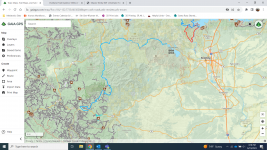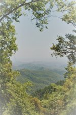
Hey guys - just got back from our attempt at the Shasta BDT and wanted to give everyone an update on the state of the titled trail. While some places are likely accessibly below 5k feet. Anything above 5k is a toss up (especially the sections above 6k ft). Our crew of 3 (Tacoma, F150, Silverado 1500) had a smooth run at the start of the trail off 36, however about 14ish miles in we ran into what looked like a 10' - 15' deep snow pack completely blocking any further movement (40.27070, -123.27975). Elevation at this point is roughly 5700~ ft. It looks like you could approach it an aggressive angle however one small mistake and you're sliding down the mountainside. Even if we did get through this one, there's likely another similar blockage or even downed tree(s) (one pictured just 40yds beyond this snowpack) since it's likely not maintained. In any case, we had to back track and for the sake of time we drove from the 36 to the 3 through Hayfork straight to our camping site @ steel bridge (which I highly recommend if you can get a spot). We did check out the section of the BDT that connects to the 3 so you could traverse it backwards to try and get to deerlick campgrounds. We didn't go in that far so not certain how far back you could access. Next day got a super late start and was supposed to be at Lake Siskiyou before end of the day so we checked out the section through the french gulch and that seemed fine however be warned that leg will eventually reach 6k feet (I've got an alt route plotted that we never took, so anyone interested I can provide the gpx file). All in all the overland attempt was pretty dismal however the 3 of us have never been in that area so we left feeling pretty satisfied with the overall experience. Night 1 was spent at mad river, Night 2 was steel bridge, and the final night was Lake Siskiyou. We had (2) 9 year old boys with us so we wanted to give them some kick back campground time hence the tight timelines. Definitely didn't help that we had late starts every day. Lotta lessons learned this trip but we will definitely be back to try again.


.jpg")