>>> You must have an RSVP/Ticket to attend this event <<<
Tix available on the OTG events/tours page.
Dates: Thurs Apr 13-16
OTG Crew will be arriving Thursday evening to secure our campsites (look for the big, blue Ram w/ camper!). If you arrive before us, try to secure a nice spot for the group. We will have a larger group (approx 30+ rigs). You're welcome to arrive early and snag an optimal campsite.
We may end up setting up specific areas for families with kids (quite area pass 10pm), and a separate area for folks who would like to party into the night.
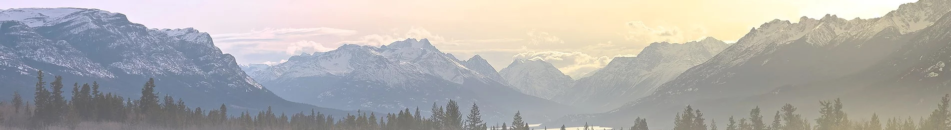
Location: Oak Flat Campground at Lake Pillsbury, Mendocino NF
Oak Flat Campground provides plenty of room to camp as a group, or away from the group is you desire.
GPX Directions from Redwood Valley (just north of Ukiah)
Be sure to take Hwy 20 to Potter Valley. Elk Mountain Road/M1/Road 301 is closed north of Upper Lake. FH7 is likely to be impassable due to snow as well.
Google Maps Location (please take the route shown in the gpx file above).
The Basics/ Things to Know
Activities
The Lake Pillsbury Basin provides options for a ton of outdoor activities, including but not limited to:
You're welcome to bring your dogs as long as they get along with other dogs and people. If your pet behaves in an aggressive manner, we will ask you to tie them up safely away from the main camp.
Swimming
It looks like we could see temps into the 70s potentially. If you want to test the waters, there's a nices swimming hole located at the location below. You'll need to look for an entrance between some small boulders, then follow the trail down to the river bar.
Libations
We'll have a variety of beers for sampling (approx 2 cans/bottles per paying vehicle), along with some higher end whiskey, bourbon, and tequila.
Lottery for Swag
We'll be raffling off OTG swag on Saturday evening. Each paying vehicle will be provided with a free raffle ticket.
Campfires/Firewood
Campfire are currently allowed. Please bring firewood if you can!
Hiking
Bloody Rock Trail can be reached reached by following the Game Reserve Track in the trail runs section. The hike to Bloody rock is approximately 1.5 miles out-and-back, or if you're up for something a big more laborious, consider the 4 mile out-and-back trek down to the Eel River below. Location of the Bloody Rock Trailhead (also shows up on the Gaia basemap layer): 39.48342, -122.85715
Trail Runs - Friday + Saturday
Trail Runs are a bit in the air with snow levels, which are down to around 4k feet. It's also quite possible you may encounter deadfall from the numerous winter storms that hit NorCal this winter. We'll keep each group to 12 or less vehicles so as not to cause too much trail traffic. If you're up for being a trail lead (leading the group), let us know!
Friday Trail Run: 1pm
Saturday Trail Run: 10am
Trail Run Options:
The Game Reserve // Download GPX File (2-3 hours, suitable for all vehicles)
This particular trail run goes up Hull Mountain via Road M1 until you hit snow (probably 4-4500'). Retrace your tracks and then take M6 into the game reserve. The game reserve parallels the headwaters of the Eel River, and there are a few locations you can get down to the river-- just be mindful of group size when it comes to turning around. Go as far as you can on M6 until you hit snow then turn around.
Pine Mountain + Bear Creek // Download GPX File (3-5 hours, 4x4 recommended for Rice Fork creek crossing)
This route travels south along M1 towards upper lake and visits the Pine Mountain Fire Lookout along the way (may be inaccessible if lots of deadfall). Then take the road down towards Bear Creek Campground and across the Rice Fork creek crossing. Given all of the snow, and potential snowmelt, it's possible the creek may not be safe for crossing. We recommend checking the situation beforehand and using common sense to assess the situation before making an attempt. In normal years, the creek can be easily crossed be a stock 4x4 this time of year. If the group makes it across, you can explore Bear Creek Campground to the right, and then take the road up towards Bowery Flat and see how high you get up before hitting snow.
4x4 Trails -- OHV System Closed thru Jone
Unfrotunately, all OHV trails in the Upper Lake Ranger Districte are closed to vehicle traffic through June. If you have a mountain bike, technically, you're in a bit of a grey area since a bike doesn't qualify as a motor vehicle.
MTB Trails (click for Upper Lake OHV Trail)
We recommend using the Trail Forks App or Trail Forks layer in Gaia GPS (may have different names than below). Shuttle/ebike friendly trails in the Lake Pillsbury Basin include:
Tix available on the OTG events/tours page.
Dates: Thurs Apr 13-16
OTG Crew will be arriving Thursday evening to secure our campsites (look for the big, blue Ram w/ camper!). If you arrive before us, try to secure a nice spot for the group. We will have a larger group (approx 30+ rigs). You're welcome to arrive early and snag an optimal campsite.
We may end up setting up specific areas for families with kids (quite area pass 10pm), and a separate area for folks who would like to party into the night.
Location: Oak Flat Campground at Lake Pillsbury, Mendocino NF
Oak Flat Campground provides plenty of room to camp as a group, or away from the group is you desire.
GPX Directions from Redwood Valley (just north of Ukiah)
Be sure to take Hwy 20 to Potter Valley. Elk Mountain Road/M1/Road 301 is closed north of Upper Lake. FH7 is likely to be impassable due to snow as well.
Google Maps Location (please take the route shown in the gpx file above).
The Basics/ Things to Know
- Bring your best self and be respectful to other campers. We're all here to have fun!
- Tread lightly and leave no trace. Let's leave it better than we found it!
- No drinking while out on Trail Runs. Drinking and driving will not be tolerated.
- If you plan on target shooting, please stow all guns in a safe and secure (locked) location out of view from others while at camp. See info below for target shooting info.
Activities
The Lake Pillsbury Basin provides options for a ton of outdoor activities, including but not limited to:
- Free Raffle for OTG Swag
- 4x4 trails -- we'll provide a 2-3 different options for folks who would like to go exploring during the day on Friday and Saturday (tbd depending on snow levels). Options will range from 4x4 only to AWD/softroad routes. More info + GPX files will be posted here as the date nears.
- Mountain Biking (there are 2-3 DH oriented trails in the basin that can be shuttled with a vehicle or ebike, more moto trails within a 20-30 minute drive of camp as well. More info on recommended trails below.
- OHV Trails are unfortunately closed thru June

- Swimming/water activities (dependent on the weather, but there are some great places to swim at the lake as well we Eel River
- RC Trucks-- bring them if you have them!
- Target Shooting at end of Gravelly airstrip against the hill-- you're welcome to go target shooting. We ask that you keep all firearms locked and stowed away in a private location when at camp.
You're welcome to bring your dogs as long as they get along with other dogs and people. If your pet behaves in an aggressive manner, we will ask you to tie them up safely away from the main camp.
Swimming
It looks like we could see temps into the 70s potentially. If you want to test the waters, there's a nices swimming hole located at the location below. You'll need to look for an entrance between some small boulders, then follow the trail down to the river bar.
39.407785, -122.990030
Libations
We'll have a variety of beers for sampling (approx 2 cans/bottles per paying vehicle), along with some higher end whiskey, bourbon, and tequila.
Lottery for Swag
We'll be raffling off OTG swag on Saturday evening. Each paying vehicle will be provided with a free raffle ticket.
Campfires/Firewood
Campfire are currently allowed. Please bring firewood if you can!
Hiking
Bloody Rock Trail can be reached reached by following the Game Reserve Track in the trail runs section. The hike to Bloody rock is approximately 1.5 miles out-and-back, or if you're up for something a big more laborious, consider the 4 mile out-and-back trek down to the Eel River below. Location of the Bloody Rock Trailhead (also shows up on the Gaia basemap layer): 39.48342, -122.85715
Trail Runs - Friday + Saturday
Trail Runs are a bit in the air with snow levels, which are down to around 4k feet. It's also quite possible you may encounter deadfall from the numerous winter storms that hit NorCal this winter. We'll keep each group to 12 or less vehicles so as not to cause too much trail traffic. If you're up for being a trail lead (leading the group), let us know!
Friday Trail Run: 1pm
Saturday Trail Run: 10am
Trail Run Options:
The Game Reserve // Download GPX File (2-3 hours, suitable for all vehicles)
This particular trail run goes up Hull Mountain via Road M1 until you hit snow (probably 4-4500'). Retrace your tracks and then take M6 into the game reserve. The game reserve parallels the headwaters of the Eel River, and there are a few locations you can get down to the river-- just be mindful of group size when it comes to turning around. Go as far as you can on M6 until you hit snow then turn around.
Pine Mountain + Bear Creek // Download GPX File (3-5 hours, 4x4 recommended for Rice Fork creek crossing)
This route travels south along M1 towards upper lake and visits the Pine Mountain Fire Lookout along the way (may be inaccessible if lots of deadfall). Then take the road down towards Bear Creek Campground and across the Rice Fork creek crossing. Given all of the snow, and potential snowmelt, it's possible the creek may not be safe for crossing. We recommend checking the situation beforehand and using common sense to assess the situation before making an attempt. In normal years, the creek can be easily crossed be a stock 4x4 this time of year. If the group makes it across, you can explore Bear Creek Campground to the right, and then take the road up towards Bowery Flat and see how high you get up before hitting snow.
4x4 Trails -- OHV System Closed thru Jone
Unfrotunately, all OHV trails in the Upper Lake Ranger Districte are closed to vehicle traffic through June. If you have a mountain bike, technically, you're in a bit of a grey area since a bike doesn't qualify as a motor vehicle.
MTB Trails (click for Upper Lake OHV Trail)
We recommend using the Trail Forks App or Trail Forks layer in Gaia GPS (may have different names than below). Shuttle/ebike friendly trails in the Lake Pillsbury Basin include:
- Trail 61 (super fast and flowy singletrack can easily be shuttled, 10 min from camp)
- Trail 63, Browns Bulch (steep moto trail with erosion ruts, 15 min from camp)
- Trail 64, Lower Powderhouse (15 min from camp, high speed wider trail with big waterbars to boost off of)
- Trail 37 (drops down towards Bear Creek Campground area near the Rice Fork, 20+ min from camp)
- Trail 1, sled Ridge (2500' drop on a fast and flowy moto trail, this one is closer to Penny Pines Campground, about a 40 min drive from camp but probably the best/longest DH trail of the bunch)
Last edited:

 Or as a Marin native too, maybe a little Marin Brew Co. Love me some red ale.