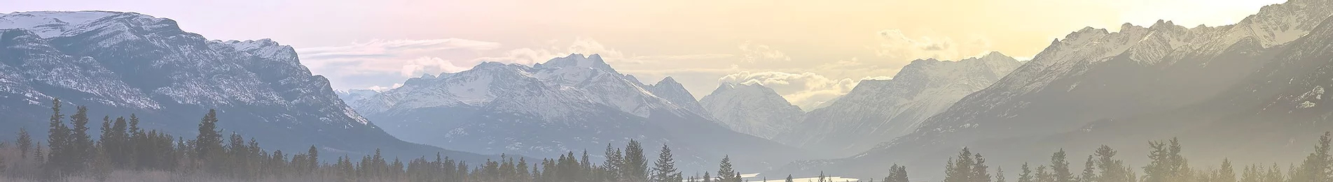
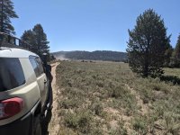
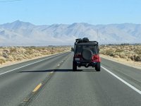
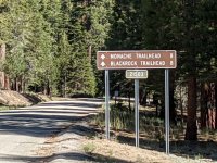
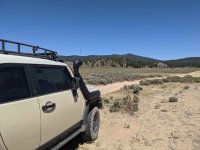
A small group of intrepid explorers decided to make a last-minute trip to Monache Meadows in California's Eastern Sierra Mountains. We had four well equipped expedition vehicles which consisted of a Toyota FJ Cruiser, Toyota 4 Runner and two Jeeps, one TJ and one YJ. The hastily developed plan was to leave So Cal at 0500 on Saturday morning and meet up along the road. We are all licensed hams and initial communications was on Yaesu Fusion digital frequencies via the So Cal ham network (www.socalham.com for more info). Our timing was just about perfect, and we were all within three miles of each other as we linked up on the N/B 15 in Norco. Our first stop was Kramer Junction where we stopped to fill up with gas. Gas was about 75 cents a gallon cheaper here than at our next stop which was the Shell station in Pearsonville. We topped off in Pearsonville and made a last check of our gear before starting up Nine Mile Canyon up towards Kennedy Meadows and the mountain communities. At this point we all switched over to simplex communications on the radios. Cell service ends not too far up Nine Mile Canyon so plan accordingly. It is about a 37-mile drive on paved roads to the Black Rock Visitor Center and the first turn off towards Monache Meadows. From the visitor center to the turn, off pavement is another seven miles of paved road. At the turn off, we all pulled over, aired down and made one last gear check to make sure everything was tied down securely. Once our little caravan was ready, we hit the dirt.
About a mile and a half in off the pavement we hit our first obstacle. Several vehicles warned us a tree had fallen late the night before just ahead and blocked the trail. We decided to go look for ourselves and assess the situation. A little further down the trail on a fairly steep downhill there was indeed a tree down across most of the trail. It was in a rocky section with soft dirt in between and maybe a little off camber, but it certainly looked passable. I put the FJ in 4 low for better traction and led our group around the obstacle without difficulty and plenty of room to spare. There will be more later on in the trip report about this obstacle, vehicles, equipment and skill set. With that behind us, we continued our journey and exploration of Monache Meadows.
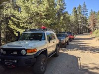
Here I will address trail conditions and vehicle equipment and requirements. This trail requires a “high clearance” vehicle. What is “high clearance” exactly I cannot define, but you are not getting a Prius or Accord into this back country. I did see a couple of well-equipped Subaru's (a CrossTrek and Forester) with some lift, getting around and crossing the river and they were not having any difficulty. I did hear they took some pretty good body damage getting back out and back on pavement because the trail conditions had changed in 24 hours. There were also several two-wheel drive pick up's and SUV's up in the meadow. Most of the trails were easily conquered in two-wheel drive and there were others where four-wheel drive made it that much easier. Most of the trail is dirt road with a few more technical sections thrown in to keep it interesting. The scenery is fantastic and views incredible. There were several sections where we watched the two-wheel drive vehicles struggle up steeper, rocky portions of the trail. They ended up spinning their wheels and digging deep ruts and potholes that tore up the trail and made it more difficult for everyone else. Personally, I feel that is a bit irresponsible. When people tear up the trails and make it more difficult, others try to make a new path around the obstacle which only makes things worse for everyone and the environment. To me it is not wheeling responsibly and following the “leave no trace” motto that we all try to follow. I will step off the high horse now and get back to the report.
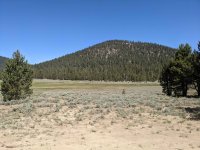
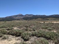
As I mentioned previously the views are amazing with grassy meadows, pine trees, redwoods and even a few poplar trees along the trail. The peaks stood in stark contrast to the blue skies which did not have a cloud in them the two days we were exploring. I will also mention the weather. Elevation is around 8,500 feet and it was in the mid-seventies during the day and got down into the high thirties at night. Meanwhile, down in the valley along the 395, the temperature was hovering around the century mark.
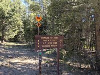
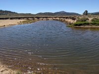
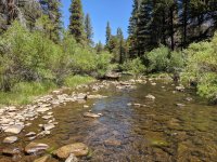
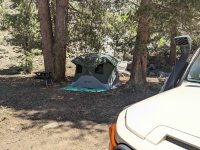
Once we entered Monache Meadows proper the views opened up and we followed the trail to the first opportunity for a water crossing of the south fork of the Kern River. This trip occurred in mid-June and there were only three water crossings, and all were optional. You can stay on the west side of the river and not need to cross the water at all. The water level will obviously vary depending on the time of year you arrive and there was evidence of many more water crossings if you arrive in early spring at the height of the snow melt. I didn't get out and measure, but I would estimate the water was about 2 feet deep at the deepest part of the crossing. There was a sand bar area you could use and cross in about 6 inches of water but where is the fun in that? We passed on the water crossing on our way into camp because there was already another group of about eight vehicles there, so we pressed on to the end of the trail. At the north end of the trail there is an area called the river campsites. These are undeveloped camp spots without any services. There is another water crossing here that leads to another area of campsites, some of which are right along the river. The water there was only about a foot deep. We crossed the river and found an empty campsite at around 11:00 am. It took us about six hours to get from home to campsite taking our time and enjoying the scenery.
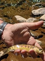
We set up camp and we were having lunch by 11:30. After lunch we broke out the fly rods and headed the 50 yards or so over to the river and started fishing. The river is filled with Brown Trout and there are some Golden's in there too. We fished for a couple of hours, and I caught four and lost at least as many. The fishing here is all on artificial, fly's and lures with barb-less hooks. I am a beginning fly fisherman and don't really know what I am doing. John is an expert fly fisherman and he caught at least twenty. The fish are all small, palm sized and were caught and released. Don't plan on catching your dinner because these are all really fun to catch but not big enough to eat.
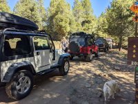
Dale and I put the fishing poles away and loaded back up for more exploring the roads around the meadow. I use Gaia on my Samsung tablet for navigation, and I had downloaded the topo and USFS road maps for offline use. We spent the next couple hours following the roads to their dead ends and then turned around and followed them off to another spur. There are numerous ranches in the area that are fenced off and we respected the fences and private property signs. On this drive we crossed the river twice and both crossing was as described earlier. They are all deep enough to wash the dust off the undercarriage. After running all the trails to their termination, we headed back into camp to rustle up some dinner. At this time of year there are no open flames or campfires allowed but you can use a gas stove after you get your California fire permit. You can get yours online for free here after watching a two-minute video and taking a short test. https://www.readyforwildfire.org/permits/campfire-permit/
After dinner we all pulled up a chair and started swapping the usual campfire stories and tall tales. We couldn't make smore's without a campfire, so we settled for a tub of Red Vines and a big bag of black licorice. We talked into the night while observing an awesome star filled sky. We tracked various satellites as they passed overhead and saw a few shooting stars as well. The night sky was spectacular.
The next morning, we were all up by 0730 (some much earlier) to frosty temps in the high 30's. We made breakfast and then broke down camp while we waited for it to warm up a bit. By 0900 everything was packed away minus the fishing gear, and we set out to fish. We hiked about 4 tenths of a mile upstream where we found a nice little dam spanning the river. That was the boundary for the Golden Trout Wilderness, and we fished the area for a few hours with the same result as the day before. If you know what you are doing, you will catch a fish. The little valley along the river was idyllic and the views stunning.
After fishing, we headed back to camp to finish up packing up our gear and grabbing a snack before starting for home. A quick word here about hydration. Bring twice as much water as you think you need and drink often. It is very easy to get dehydrated and not even realize it. In the 36 hours or so hours of this trip I drank six cans of coke and eight, half liter bottles of water and lets just say I did not “water” many bushes.
After packing up we headed out around 1:00 pm because we wanted to get home a little later and miss all the traffic in the Cajon Pass. We took our time leaving the meadow and detoured around a bit to make sure we hit all three water crossings and took the obligatory photos and video. On our way out we were approaching the area where the log had fallen Friday night. We came upon a traffic jam and there were three or four rigs ahead of me. We waited a few minutes and then I got out to chat with the guy ahead of me. He confirmed my suspicions, that someone was stuck, and they were working to get him out. My back was a bit sore, so I returned to the FJ figuring I would let those younger guys figure it out. (I could see six or seven of them all scrambling around). About 15 minutes later our patience ran out and our curiosity peaked so Bob, John and Dale walked up to get a firsthand look at what was going on. A minute or two later they radioed back that a two-wheel drive Tacoma was good and stuck and it was going to take some straps, a winch and a shovel to get this guy unstuck and off the trail. It took a bit to get the other vehicles ahead of me to get to the side of the trail so I could get up there with my winch. I had to go off the trail and it was a little dicey to get around him but there was no other choice. By this time, the four of us in our group figured out no one else knew what to do or had the tools and equipment necessary to resolve the issue we took charge of the recovery operation. By now the “peanut gallery” watching this little operation had grown to about 20 people all with their cell phones out videoing the progress. I got turned around and got the FJ in position for the winch pull. John sat in the driver’s seat with his foot on the brake, ready should anything go sideways. We blocked the wheels in the FJ so we wouldn't just winch ourselves down to him. I attached the synthetic winch line to the tow loop on the Tacoma with my new soft shackles. Meanwhile Bob and Dale were using our shovels to dig out around the wheels and get him ready for the pull. After everything was set up, we pulled him up and around the obstacle fairly easy. Once he was on firmer ground, we unhooked everything and the Tacoma driver gunned it up the last steep section still spinning his tires all while the peanut gallery is screaming GO, Go, Go, GO...... It was pretty hilarious. The Tacoma guy managed a quick thanks and he was on his way! I think he was embarrassed he held everyone up and was worried the mob might turn on him.
After that it was an uneventful return to pavement where we aired up and struck out for home.
A quick postscript/commentary on traveling in the back country. Never go alone and have the proper gear, training and experience to get yourself out a jam. Remember trail conditions can change quickly and what was once easy on the way in may become impassable on the way out. I am going to steal a couple of slogans from my friends at https://thirtysecondsout.com/ ; “expect to self-rescue, no one is coming”, and “hope is not a good plan”.
Monache Meadows is a beautiful get-a-way and I look forward to doing this trip again!
Photos and GPS
About a mile and a half in off the pavement we hit our first obstacle. Several vehicles warned us a tree had fallen late the night before just ahead and blocked the trail. We decided to go look for ourselves and assess the situation. A little further down the trail on a fairly steep downhill there was indeed a tree down across most of the trail. It was in a rocky section with soft dirt in between and maybe a little off camber, but it certainly looked passable. I put the FJ in 4 low for better traction and led our group around the obstacle without difficulty and plenty of room to spare. There will be more later on in the trip report about this obstacle, vehicles, equipment and skill set. With that behind us, we continued our journey and exploration of Monache Meadows.
Here I will address trail conditions and vehicle equipment and requirements. This trail requires a “high clearance” vehicle. What is “high clearance” exactly I cannot define, but you are not getting a Prius or Accord into this back country. I did see a couple of well-equipped Subaru's (a CrossTrek and Forester) with some lift, getting around and crossing the river and they were not having any difficulty. I did hear they took some pretty good body damage getting back out and back on pavement because the trail conditions had changed in 24 hours. There were also several two-wheel drive pick up's and SUV's up in the meadow. Most of the trails were easily conquered in two-wheel drive and there were others where four-wheel drive made it that much easier. Most of the trail is dirt road with a few more technical sections thrown in to keep it interesting. The scenery is fantastic and views incredible. There were several sections where we watched the two-wheel drive vehicles struggle up steeper, rocky portions of the trail. They ended up spinning their wheels and digging deep ruts and potholes that tore up the trail and made it more difficult for everyone else. Personally, I feel that is a bit irresponsible. When people tear up the trails and make it more difficult, others try to make a new path around the obstacle which only makes things worse for everyone and the environment. To me it is not wheeling responsibly and following the “leave no trace” motto that we all try to follow. I will step off the high horse now and get back to the report.
As I mentioned previously the views are amazing with grassy meadows, pine trees, redwoods and even a few poplar trees along the trail. The peaks stood in stark contrast to the blue skies which did not have a cloud in them the two days we were exploring. I will also mention the weather. Elevation is around 8,500 feet and it was in the mid-seventies during the day and got down into the high thirties at night. Meanwhile, down in the valley along the 395, the temperature was hovering around the century mark.
Once we entered Monache Meadows proper the views opened up and we followed the trail to the first opportunity for a water crossing of the south fork of the Kern River. This trip occurred in mid-June and there were only three water crossings, and all were optional. You can stay on the west side of the river and not need to cross the water at all. The water level will obviously vary depending on the time of year you arrive and there was evidence of many more water crossings if you arrive in early spring at the height of the snow melt. I didn't get out and measure, but I would estimate the water was about 2 feet deep at the deepest part of the crossing. There was a sand bar area you could use and cross in about 6 inches of water but where is the fun in that? We passed on the water crossing on our way into camp because there was already another group of about eight vehicles there, so we pressed on to the end of the trail. At the north end of the trail there is an area called the river campsites. These are undeveloped camp spots without any services. There is another water crossing here that leads to another area of campsites, some of which are right along the river. The water there was only about a foot deep. We crossed the river and found an empty campsite at around 11:00 am. It took us about six hours to get from home to campsite taking our time and enjoying the scenery.
We set up camp and we were having lunch by 11:30. After lunch we broke out the fly rods and headed the 50 yards or so over to the river and started fishing. The river is filled with Brown Trout and there are some Golden's in there too. We fished for a couple of hours, and I caught four and lost at least as many. The fishing here is all on artificial, fly's and lures with barb-less hooks. I am a beginning fly fisherman and don't really know what I am doing. John is an expert fly fisherman and he caught at least twenty. The fish are all small, palm sized and were caught and released. Don't plan on catching your dinner because these are all really fun to catch but not big enough to eat.
Dale and I put the fishing poles away and loaded back up for more exploring the roads around the meadow. I use Gaia on my Samsung tablet for navigation, and I had downloaded the topo and USFS road maps for offline use. We spent the next couple hours following the roads to their dead ends and then turned around and followed them off to another spur. There are numerous ranches in the area that are fenced off and we respected the fences and private property signs. On this drive we crossed the river twice and both crossing was as described earlier. They are all deep enough to wash the dust off the undercarriage. After running all the trails to their termination, we headed back into camp to rustle up some dinner. At this time of year there are no open flames or campfires allowed but you can use a gas stove after you get your California fire permit. You can get yours online for free here after watching a two-minute video and taking a short test. https://www.readyforwildfire.org/permits/campfire-permit/
After dinner we all pulled up a chair and started swapping the usual campfire stories and tall tales. We couldn't make smore's without a campfire, so we settled for a tub of Red Vines and a big bag of black licorice. We talked into the night while observing an awesome star filled sky. We tracked various satellites as they passed overhead and saw a few shooting stars as well. The night sky was spectacular.
The next morning, we were all up by 0730 (some much earlier) to frosty temps in the high 30's. We made breakfast and then broke down camp while we waited for it to warm up a bit. By 0900 everything was packed away minus the fishing gear, and we set out to fish. We hiked about 4 tenths of a mile upstream where we found a nice little dam spanning the river. That was the boundary for the Golden Trout Wilderness, and we fished the area for a few hours with the same result as the day before. If you know what you are doing, you will catch a fish. The little valley along the river was idyllic and the views stunning.
After fishing, we headed back to camp to finish up packing up our gear and grabbing a snack before starting for home. A quick word here about hydration. Bring twice as much water as you think you need and drink often. It is very easy to get dehydrated and not even realize it. In the 36 hours or so hours of this trip I drank six cans of coke and eight, half liter bottles of water and lets just say I did not “water” many bushes.
After packing up we headed out around 1:00 pm because we wanted to get home a little later and miss all the traffic in the Cajon Pass. We took our time leaving the meadow and detoured around a bit to make sure we hit all three water crossings and took the obligatory photos and video. On our way out we were approaching the area where the log had fallen Friday night. We came upon a traffic jam and there were three or four rigs ahead of me. We waited a few minutes and then I got out to chat with the guy ahead of me. He confirmed my suspicions, that someone was stuck, and they were working to get him out. My back was a bit sore, so I returned to the FJ figuring I would let those younger guys figure it out. (I could see six or seven of them all scrambling around). About 15 minutes later our patience ran out and our curiosity peaked so Bob, John and Dale walked up to get a firsthand look at what was going on. A minute or two later they radioed back that a two-wheel drive Tacoma was good and stuck and it was going to take some straps, a winch and a shovel to get this guy unstuck and off the trail. It took a bit to get the other vehicles ahead of me to get to the side of the trail so I could get up there with my winch. I had to go off the trail and it was a little dicey to get around him but there was no other choice. By this time, the four of us in our group figured out no one else knew what to do or had the tools and equipment necessary to resolve the issue we took charge of the recovery operation. By now the “peanut gallery” watching this little operation had grown to about 20 people all with their cell phones out videoing the progress. I got turned around and got the FJ in position for the winch pull. John sat in the driver’s seat with his foot on the brake, ready should anything go sideways. We blocked the wheels in the FJ so we wouldn't just winch ourselves down to him. I attached the synthetic winch line to the tow loop on the Tacoma with my new soft shackles. Meanwhile Bob and Dale were using our shovels to dig out around the wheels and get him ready for the pull. After everything was set up, we pulled him up and around the obstacle fairly easy. Once he was on firmer ground, we unhooked everything and the Tacoma driver gunned it up the last steep section still spinning his tires all while the peanut gallery is screaming GO, Go, Go, GO...... It was pretty hilarious. The Tacoma guy managed a quick thanks and he was on his way! I think he was embarrassed he held everyone up and was worried the mob might turn on him.
After that it was an uneventful return to pavement where we aired up and struck out for home.
A quick postscript/commentary on traveling in the back country. Never go alone and have the proper gear, training and experience to get yourself out a jam. Remember trail conditions can change quickly and what was once easy on the way in may become impassable on the way out. I am going to steal a couple of slogans from my friends at https://thirtysecondsout.com/ ; “expect to self-rescue, no one is coming”, and “hope is not a good plan”.
Monache Meadows is a beautiful get-a-way and I look forward to doing this trip again!
Photos and GPS
Attachments
-
 PXL_20210612_172715339.jpg4.8 MB · Views: 2
 -
 PXL_20210612_145156703.jpg1.5 MB · Views: 2
 -
 PXL_20210612_151854834.jpg3.3 MB · Views: 2
 -
 PXL_20210612_161713926.jpg2.1 MB · Views: 2
 -
 PXL_20210612_163351504.jpg5.4 MB · Views: 4
 -
 PXL_20210612_163423845.jpg6.2 MB · Views: 2
 -
 PXL_20210612_163431593.jpg5 MB · Views: 2
 -
 PXL_20210612_174335444.jpg4.3 MB · Views: 1
 -
 PXL_20210612_175648304.jpg3.7 MB · Views: 1
 -
 PXL_20210612_180925813.jpg4.5 MB · Views: 1
 -
 PXL_20210612_180938579.jpg3.8 MB · Views: 1
 -
 PXL_20210612_184510715.jpg6.1 MB · Views: 1
 -
 PXL_20210612_192521618.jpg4.9 MB · Views: 3
 -
 PXL_20210612_212412982.jpg766 KB · Views: 5
 -
 PXL_20210612_234633595.jpg6.4 MB · Views: 3
