overland

Washington Cascades Adventure Route

OTG Ben

OTG Principal Explorer
Staff member
Admin
Joined
Apr 24, 2021
Messages
470
Location
NorCal
Include the Following for all Status Updates

Date:
Current Status:
Additional Details:


Example of a Trail Update for a Route

Date:
4/30/2022

Current Status: Open with some issues

Additional Details: Recent rains have caused the river levels to rise substantially. Buffalo River is approximately 3' deep. Lifted vehicles with larger tires (33" +) may find it difficult and/or dangerous to cross Buffalo River. There's another crossing that's about 30" deep 1/2 mile north of the main crossing. We recommend checking water levels first, but this is typically the alternative crossing point. Aside from water levels, the rest of the trail is running fantastic!
 

Troysmit-8026

Trail Grom
Joined
Nov 14, 2021
Messages
2
Date: 8/21/2022
Current Status: Open with some issues.
Trip Report: link
Additional Details: Ran most of this route last week. Mostly conditions were good.

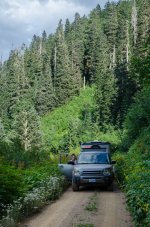
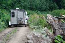
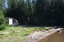
NF-6801 that starts at 45.90675, -121.80703 quickly became very overgrown and appears to not be used much. No way you'd want to take a van down it, or anything that you care much about your paint. I have a Land Rover LR3 and a 6x10 cargo trailer camper conversion that we take into fairly rugged roads / light trails and eventually the going became too slow with all the overhanging branches. I'm not that worried about the paint (the Rover wears its many pinstripes with pride!) but the trailer is around 8' tall (maybe more?) and the wheels stick out a bit wider than the tow vehicle. We bailed out back to NF-60 and then NF-65 (narrow paved forest access road) to complete the last part of the trip.


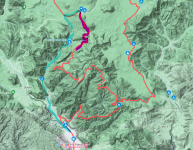
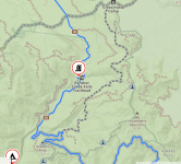
Bottom part of loop shown below. Purple highlight is section we entered and then gave up on overgrown route and backed up, took blue highlighted alternate route. I have to wonder if anyone from OLT has actually driven that section, it seems pretty unused. It was not impassable but was frustratingly overgrown and my experience with those kinds of roads is that they usually get worse and worse the deeper you get, so we turned around before it got really bad. It was late in the evening and we needed to be making camp, not bushwacking.

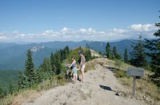
I seem to have a difficult time with Gaia and any other routing/tracking apps, despite being a reasonably digital-capable person. The tablet did not save our route so i don't know exactly how far we got down that road but i probably backed the trailer up through the bushes for close to an hour before getting to a spot clear enough to turn around. That's a gamble i take by taking the trailer. It was also a little sketchy to turn around on top of the Burley Mountain Fire Lookout, but worth it.
1661918954803.png


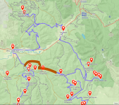
Also, due to time restraints we skipped the upper portion of the loop. In the image below, the orange-highlighted path is the route that we took, skipping from near DP19 over to the town of Randle, via FS Road 55. We tried to take a side route off of that, up to the top of Lone Tree mtn, but the road was washed out and we were not able to make it to the top. In any case, i can't speak to any of the conditions from DP19-24 as we didn't go there. Sad to miss getting close to Rainier but that's the way the timing worked. We left home in Bend OR sunday morning and got back saturday afternoon. It's about 3 hours from Bend to Carson, WA where we began/finished the route.

1661920036667.png
 

Attachments

  • 20220825 Gifford Pinchot Camp Trip-094_w.jpg
    20220825 Gifford Pinchot Camp Trip-094_w.jpg
    265.9 KB · Views: 9
  • 20220824 Gifford Pinchot Camp Trip-046_w.jpg
    20220824 Gifford Pinchot Camp Trip-046_w.jpg
    407.9 KB · Views: 8
  • 20220824 Gifford Pinchot Camp Trip-041_w.jpg
    20220824 Gifford Pinchot Camp Trip-041_w.jpg
    401 KB · Views: 8
  • 20220822 Gifford Pinchot Camp Trip-015_w.jpg
    20220822 Gifford Pinchot Camp Trip-015_w.jpg
    324.7 KB · Views: 7
Last edited:

OTG Ben

OTG Principal Explorer
Staff member
Admin
Joined
Apr 24, 2021
Messages
470
Location
NorCal
Hey @Troysmit-8026

Thanks for the heads up. It looks like there was a bug when creating the gpx file, as somehow there are two tracks/versions of the route. One is old version (including the trail that you took and had to turn around) and the other is the current version which skirts that section (this should have been the only one in the file). You wouldn't have been able to make it through anyways, as there is a known washout that we confirmed prior to publishing the app. We'll be cleaning up the GPX file so it only contains a single track to avoid confusion down the road. Thanks for posting photos as well!

This is the intended route:

1661985439412.png
 
Last edited:
Top