Amazing trip, and the route was excellent.
We started in Denver, and decided that we would start on the northwest side and run the route backwards. I-70 spring break traffic was typical, and it took us about 3 hours longer to get out of Colorado than I would have liked. Found a camping spot near the dry lake on Highway 50 in Utah near the Nevada border.
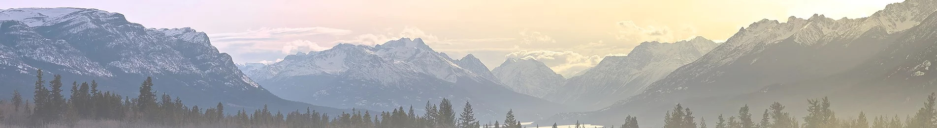
2nd day took us to Lone Pine. We tried to find a spot in the Alabama Hills, but we didn't get there until about 5:30, so everything was pretty much taken. We started up the hard route on the West side (up Cerro Gordo), but as it got dark, I figured it was more of a challenge than I wanted to deal with, so we ended up just getting a hotel for the night. The wind had been rough the last couple of days, and I didn't want to stay out where we'd be completely exposed.
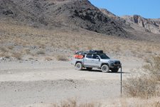
3rd day got us into the park. We meandered, going over to the Father Crowley Overlook before heading up Saline Valley. The road is generally good, with a fair amount of washboarding here and there. The forests of Joshua trees were just beautiful. We tried to get to the salt tram again, but with as loaded down as my truck was, we decided that it was getting rougher than I wanted to manage, especially solo. So, after this, we pretty much stayed on the easy route.
With the wind being rough still, we were fortunate enough to find a sheltered spot near Grapevine Canyon. We could hear the wind over us, but barely felt any. Got to see several fighter jets doing practice runs through the canyon - they were much closer than I had expected! My wife is a birder, and we were visited by several very talkative birds - rock wrens especially - that just made the place really nice.
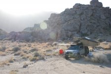
4th day took us around the valley and into Last Chance. It was still breezy, and it took us a bit to find a spot. Fortunately, there was *nobody* out there, so we were able to camp in a relatively secluded spot and enjoy the sunset.
5th day we explored quite a bit more. I was getting low on fuel at this point, and we made it to Beatty after using one of my two fuel cans.1 Titus canyon was absolutely awestriking - I'd run that canyon several times to be able to see everything. Ultimately we headed to Lemoigne Canyon and found a spot on the approach - exposed, but with so few people out we were still alone.
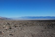
6th day we went out to see the Racetrack, finished up viewing the middle section of the Valley, and ended up at a spot at the mouth of Echo Canyon. Absolutely gorgeous - best spot of the trip by far.
7th day we started heading home by following the route out through the Southern end of the Valley, visiting some of the historic spots on the way out. The drive was great - mixed terrain from washboard to a few inches of sand. Nothing terribly challenging, which was just fine.
We probably did the route faster than we should have, but returning to work was back of mind. This was a beautiful trip at the perfect time of year, and everything was as good or better than I had hoped.
Edit: I should also add that there is a certain amount of one-way nature to the route. We had to backtrack a couple of times to make sure we covered everything. With the winds the way they were, it worked out for the best to go this way, but I can see how the other direction has a better flow.
We started in Denver, and decided that we would start on the northwest side and run the route backwards. I-70 spring break traffic was typical, and it took us about 3 hours longer to get out of Colorado than I would have liked. Found a camping spot near the dry lake on Highway 50 in Utah near the Nevada border.
2nd day took us to Lone Pine. We tried to find a spot in the Alabama Hills, but we didn't get there until about 5:30, so everything was pretty much taken. We started up the hard route on the West side (up Cerro Gordo), but as it got dark, I figured it was more of a challenge than I wanted to deal with, so we ended up just getting a hotel for the night. The wind had been rough the last couple of days, and I didn't want to stay out where we'd be completely exposed.
3rd day got us into the park. We meandered, going over to the Father Crowley Overlook before heading up Saline Valley. The road is generally good, with a fair amount of washboarding here and there. The forests of Joshua trees were just beautiful. We tried to get to the salt tram again, but with as loaded down as my truck was, we decided that it was getting rougher than I wanted to manage, especially solo. So, after this, we pretty much stayed on the easy route.
With the wind being rough still, we were fortunate enough to find a sheltered spot near Grapevine Canyon. We could hear the wind over us, but barely felt any. Got to see several fighter jets doing practice runs through the canyon - they were much closer than I had expected! My wife is a birder, and we were visited by several very talkative birds - rock wrens especially - that just made the place really nice.
4th day took us around the valley and into Last Chance. It was still breezy, and it took us a bit to find a spot. Fortunately, there was *nobody* out there, so we were able to camp in a relatively secluded spot and enjoy the sunset.
5th day we explored quite a bit more. I was getting low on fuel at this point, and we made it to Beatty after using one of my two fuel cans.1 Titus canyon was absolutely awestriking - I'd run that canyon several times to be able to see everything. Ultimately we headed to Lemoigne Canyon and found a spot on the approach - exposed, but with so few people out we were still alone.
6th day we went out to see the Racetrack, finished up viewing the middle section of the Valley, and ended up at a spot at the mouth of Echo Canyon. Absolutely gorgeous - best spot of the trip by far.
7th day we started heading home by following the route out through the Southern end of the Valley, visiting some of the historic spots on the way out. The drive was great - mixed terrain from washboard to a few inches of sand. Nothing terribly challenging, which was just fine.
We probably did the route faster than we should have, but returning to work was back of mind. This was a beautiful trip at the perfect time of year, and everything was as good or better than I had hoped.
Edit: I should also add that there is a certain amount of one-way nature to the route. We had to backtrack a couple of times to make sure we covered everything. With the winds the way they were, it worked out for the best to go this way, but I can see how the other direction has a better flow.
Attachments
-
 DSC_5246.JPG3.8 MB · Views: 9
 -
 DSC_5259.JPG4.6 MB · Views: 8
 -
 DSC_5321.JPG3.6 MB · Views: 8
 -
 DSC_5345.JPG4.5 MB · Views: 8
 -
 DSC_5358.JPG4.7 MB · Views: 7
 -
 DSC_5376.JPG4.1 MB · Views: 8