Flying_with_Falcor
Trail Grom
- Joined
- Feb 21, 2022
- Messages
- 5
Each summer my kids and I take an epic back country trip. This year we get TWO. We already went to the Black Rock Desert which was fantastic and wild.
Next on the radar is the Lassen BDT around July 18th.
I KNOW a lot can change in a few weeks for the current snow conditions. Especially with higher temperatures, the snow is rapidly melting and trails that were blocked last week are new manageable.
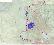
Does anyone have any good intel on the this area and route? I can see Lassen NP is still blocked in the middle due to snow, I can monitor that online.
I have download the route (which is always extremely helpful) - but I am curious if there are good campsite recommendations if we started north. I am planning on camping outside Lassen for a day or two so we can access the park by day and then wilderness camp at night. Any recommendations on just outside the park sites would be ideal.
Thanks again all and good luck out there!
Tony
Next on the radar is the Lassen BDT around July 18th.
I KNOW a lot can change in a few weeks for the current snow conditions. Especially with higher temperatures, the snow is rapidly melting and trails that were blocked last week are new manageable.
Does anyone have any good intel on the this area and route? I can see Lassen NP is still blocked in the middle due to snow, I can monitor that online.
I have download the route (which is always extremely helpful) - but I am curious if there are good campsite recommendations if we started north. I am planning on camping outside Lassen for a day or two so we can access the park by day and then wilderness camp at night. Any recommendations on just outside the park sites would be ideal.
Thanks again all and good luck out there!
Tony