In early April, we spent a few days camping and exploring the M roads north of Lake Pillsbury in the Mendocino National Forest.
Day One
The plan was to try and make it to Covelo following the M1 but snow at high elevations stopped that plan. We went in through Potter Valley and stopped at the Soda Creek store for some last minute supplies and info. They told us no one had been able to make it through yet. We decided to see how far we could get. For much of the climb from Lake Pillsbury the M1 has sunny exposures so we did not see any snow until just past the spur road to the summit. It was a deep enough drift on a steep slope to stop our progress. We had lunch, took some photos, and I walked to the summit. A group on adventure bikes road up as well. We eventually made our way down and up the M6 to a spur road that drops down to the Eel River for a sweet campspot.

Day 2 and 3
We spent time exploring the river and surrounding hillsides. There were tons of little toads about and at least 4 yellow legged frogs. We even scared up a garter snake. The weather was so warm we found a great swimming hole and made use of it.
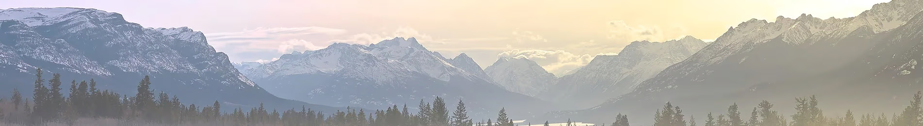
One morning I crossed the river and took a walk up a decommissioned logging road up to the old Brushy Camp Ridge rd. The old topo maps show the precursor of the M6 as a jeep track that fords the Eel and makes its way up the ridge. Later topo maps drop the road but show Brushy Ridge Rd connect to Corbin Creek and an old USFS work center. Aerial photos from before 2017 show this Brushy Camp Rd as overgrown and almost disappearing. But now it's clear that the road was opened up during the Ranch fire. It's really an extension of 19N02, but the MVUMs don't show it. I took a bunch of photos of plants and shit to document on iNaturalist. I could hear a grouse nearly my entire walk up to the ridge. Here's a view from the 19N02 looking towards Anderson Ridge.

A warden checked on us to make sure we weren't fishing. On our last night a couple showed up in their Toyota 4Runner with a snokel. They crossed the river to camp on the gravel bar across from "our" swimming hole.

Day 4
We continued up the M6 to Low Gap and M61, stopping to look for flowers and critters on the way. Came across a few deer and a number of early wildflowers. Stopped to move a gopher snake off the road. We got as far as the road to Cushman Lake but got stopped by snow again. We explored some the side roads before heading south towards Pillsbury and civilization.
Day One
The plan was to try and make it to Covelo following the M1 but snow at high elevations stopped that plan. We went in through Potter Valley and stopped at the Soda Creek store for some last minute supplies and info. They told us no one had been able to make it through yet. We decided to see how far we could get. For much of the climb from Lake Pillsbury the M1 has sunny exposures so we did not see any snow until just past the spur road to the summit. It was a deep enough drift on a steep slope to stop our progress. We had lunch, took some photos, and I walked to the summit. A group on adventure bikes road up as well. We eventually made our way down and up the M6 to a spur road that drops down to the Eel River for a sweet campspot.


Day 2 and 3
We spent time exploring the river and surrounding hillsides. There were tons of little toads about and at least 4 yellow legged frogs. We even scared up a garter snake. The weather was so warm we found a great swimming hole and made use of it.

One morning I crossed the river and took a walk up a decommissioned logging road up to the old Brushy Camp Ridge rd. The old topo maps show the precursor of the M6 as a jeep track that fords the Eel and makes its way up the ridge. Later topo maps drop the road but show Brushy Ridge Rd connect to Corbin Creek and an old USFS work center. Aerial photos from before 2017 show this Brushy Camp Rd as overgrown and almost disappearing. But now it's clear that the road was opened up during the Ranch fire. It's really an extension of 19N02, but the MVUMs don't show it. I took a bunch of photos of plants and shit to document on iNaturalist. I could hear a grouse nearly my entire walk up to the ridge. Here's a view from the 19N02 looking towards Anderson Ridge.


A warden checked on us to make sure we weren't fishing. On our last night a couple showed up in their Toyota 4Runner with a snokel. They crossed the river to camp on the gravel bar across from "our" swimming hole.

Day 4
We continued up the M6 to Low Gap and M61, stopping to look for flowers and critters on the way. Came across a few deer and a number of early wildflowers. Stopped to move a gopher snake off the road. We got as far as the road to Cushman Lake but got stopped by snow again. We explored some the side roads before heading south towards Pillsbury and civilization.

