Day 1
Back in early April, my wife LeeAnn and I headed south on a Saturday morning to Bullhead City, AZ. Our plan, to run the Mojave Road from east to west. We spent Saturday night visiting with LeeAnn’s uncle then hit the road early Sunday morning. We stopped to top off the tank and crossed the Colorado River at the Avi Casino and made our way to the eastern terminus of the Road. We backed up with the tailgate to the river and headed west. The Mojave Road was originally a Native American trading route later used by Spanish explorers and then Americans as a mail and wagon route.
First stop, Fort Paiute. Fort Paiute is a bit of a side trip off the Road but worth it. It’s pretty rocky, nothing technical, just bone jarring. There are low walls remaining at this outpost that delineate the kitchen, sleeping quarters with fireplace, and a corral for horses. There’s a nice creek and lots of greenery along its banks. Well worth the detour off the Road.
After getting back on the Road, we took the detour over the Paiute Range. This is the only part that I would consider even remotely technical, unless you consider soft sand in the bottom of washes and sand dunes technical. The road up through the pass was partially washed out and there were lots of big whoops. We watched some dirt bikes go through ahead of us and the whoops were big enough that we found one of their water bladders lying in the dirt, the straps had broken and it fell off. We were actually able to return the water bladder to its rightful owner at the old school bus location (the bus is gone by the way). A little further on, we stopped by the Penny Can Tree for lunch. Someone hung a soup can from a Joshua Tree and you’re supposed to leave a penny to contribute to the Mojave Road Maintenance Program. I was feeling like a high-roller so I left a nickel. Always willing to do my part. At some point, the Joshua Tree next to the Penny Can Tree started sprouting a bunch of plastic dinosaurs and reptiles. Something that I hadn’t heard of previously. After lunch it was on to our first night’s camp spot.
I wanted to start the road on a Sunday or Monday because I’d heard great things about a campsite off the road and up Caruthers Canyon and my hope was that it would not be occupied. While there are some developed campsites in the Mojave National Preserve (like Mid Hills and Hole in the Wall) there are numerous dispersed primitive sites throughout the route. You don’t need to create a new site, there are plenty previously used sites available. My plan worked, as we were driving up the canyon two trucks were exiting and as we reached the head of the canyon, the preferred campsite was empty and we had it all to ourselves. Hooray!
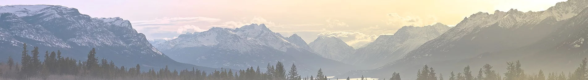
We set up our first night’s camp. This place is beautiful. It’s well over 5,000 feet in elevation so you get a respite from the desert heat. I’ve included a picture from our campsite. They call it Camp Phallus, I wonder why? The campsite is pretty popular, and there is a nice picnic table and kitchen area built from onyx and concrete, all the comforts of home. It’s a number of miles off the Road in an already remote area, so you have to have it in mind as a destination. I mention this because as we were relaxing, we heard some motorcycles coming up the canyon. A little later we heard voices coming up toward our camp. Three young men on an adventure, riding enduros from the Mexican Border to Lake Tahoe. Two were riding and the third was driving the “chase truck”, a ZR2 same as me. Small world. LeeAnn and I live in the Tri-Valley area East of the SF Bay area and as we were talking, we learned that all three worked at Sandia Labs and lived in Livermore, one town over from us. Smaller world.


Back in early April, my wife LeeAnn and I headed south on a Saturday morning to Bullhead City, AZ. Our plan, to run the Mojave Road from east to west. We spent Saturday night visiting with LeeAnn’s uncle then hit the road early Sunday morning. We stopped to top off the tank and crossed the Colorado River at the Avi Casino and made our way to the eastern terminus of the Road. We backed up with the tailgate to the river and headed west. The Mojave Road was originally a Native American trading route later used by Spanish explorers and then Americans as a mail and wagon route.
First stop, Fort Paiute. Fort Paiute is a bit of a side trip off the Road but worth it. It’s pretty rocky, nothing technical, just bone jarring. There are low walls remaining at this outpost that delineate the kitchen, sleeping quarters with fireplace, and a corral for horses. There’s a nice creek and lots of greenery along its banks. Well worth the detour off the Road.
After getting back on the Road, we took the detour over the Paiute Range. This is the only part that I would consider even remotely technical, unless you consider soft sand in the bottom of washes and sand dunes technical. The road up through the pass was partially washed out and there were lots of big whoops. We watched some dirt bikes go through ahead of us and the whoops were big enough that we found one of their water bladders lying in the dirt, the straps had broken and it fell off. We were actually able to return the water bladder to its rightful owner at the old school bus location (the bus is gone by the way). A little further on, we stopped by the Penny Can Tree for lunch. Someone hung a soup can from a Joshua Tree and you’re supposed to leave a penny to contribute to the Mojave Road Maintenance Program. I was feeling like a high-roller so I left a nickel. Always willing to do my part. At some point, the Joshua Tree next to the Penny Can Tree started sprouting a bunch of plastic dinosaurs and reptiles. Something that I hadn’t heard of previously. After lunch it was on to our first night’s camp spot.
I wanted to start the road on a Sunday or Monday because I’d heard great things about a campsite off the road and up Caruthers Canyon and my hope was that it would not be occupied. While there are some developed campsites in the Mojave National Preserve (like Mid Hills and Hole in the Wall) there are numerous dispersed primitive sites throughout the route. You don’t need to create a new site, there are plenty previously used sites available. My plan worked, as we were driving up the canyon two trucks were exiting and as we reached the head of the canyon, the preferred campsite was empty and we had it all to ourselves. Hooray!
We set up our first night’s camp. This place is beautiful. It’s well over 5,000 feet in elevation so you get a respite from the desert heat. I’ve included a picture from our campsite. They call it Camp Phallus, I wonder why? The campsite is pretty popular, and there is a nice picnic table and kitchen area built from onyx and concrete, all the comforts of home. It’s a number of miles off the Road in an already remote area, so you have to have it in mind as a destination. I mention this because as we were relaxing, we heard some motorcycles coming up the canyon. A little later we heard voices coming up toward our camp. Three young men on an adventure, riding enduros from the Mexican Border to Lake Tahoe. Two were riding and the third was driving the “chase truck”, a ZR2 same as me. Small world. LeeAnn and I live in the Tri-Valley area East of the SF Bay area and as we were talking, we learned that all three worked at Sandia Labs and lived in Livermore, one town over from us. Smaller world.


")