>>> You must have an RSVP/Ticket to attend this event <<<
Tix available on the OTG events/tours page
Dates: April 25 - 28
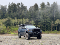
OTG Crew will be arriving Wednesday evening to secure our campsites (look for the big, blue Ram w/ camper!).
We may end up setting up specific areas for families with kids (quiiet area pass 10pm), and a separate area for folks who would like to stay up later. You're welcome to arrive as early as you please on Thursday or even before. But please not the exact location for camp will not be shared until Wednesday night.
Camp Location: We'll be camping in "the Indians" area on the eastside of Big Sur just beyond the border of Fort Hunter-Liggett. There are a number of camp locations (Camp A, Camp B, Camp C...) marked within the GPX file. On the Wednesday night before the event (April 24), be sure to check the next reply in this thread from @DPurdy85 . DPurdy85 will indicate which camp location we'll be set up at.
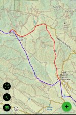
please note there is a reroute as del Venturi road is closed. Continue straight on Mission Road and and about .5 miles past del Venturi you’ll stay right when you come to three roads, this is the only road open to the public and you’ll know you’re on the right road as there are a number of orange construction barriers on your right. When you get to upper Milpitas road go left which will get bring you back to the gpx track to camp. If you’re having issues, go to the guard station that is about 1/4 mile before the turn onto del Venturi road is closed (like you’re driving into the base where buildings re)
GPX File: download link
 Look for the big blue Ram when you arrive at camp

Camp at "the Indians" area in Big Sur

Campfires
Currently there are no fire restrictions in effect. If you can, please bring firewood. Please note, anyone who operates any type of stove with a flame (propane, butane, etc), charcoal grill, or campfire must have a California Fire Permit. They only take a few minutes to get and you can get one online from Cal Fire for free HERE.
The Basics/ Things to Know
Lottery for Swag
We'll be raffling off OTG swag on Saturday evening. If you bought a ticket, your name will automatically be entered into the raffle.
Iron Chef Overland Edition - The Taco Challenge
Contest will take place Saturday evening (judging begins at 7pm)
Taco Challenge Sign Up Form (contains contest guidelines)
Activities
Pets
You're welcome to bring your dogs as long as they get along with other dogs and people. If your pet behaves in an aggressive manner, we will ask you to tie them up safely away from the main camp.
Campfires/Firewood
Campfires are currently permitted in Los Padres NF. If this situation changes, we'll update this section. Bring firewood if you can and be sure to get your campfire permit from Cal Fire.
Hiking Trails
The Wagon Cave
This is a fantastic place to spend a few hours exploring the old Wagon Cave Rock. If you like scrambling over rocks, you'll love this adventure which is a few short minutes driving from camp (or you can hike there). The Esselen people used these rocks for grinding and mashing their acorn meal.
The Indian Ranch
A 1 mile out-and-back up a hill to the old Indian Ranch.
The Indians Road
A few miles down the road there's a gate preventing further access for vehicles. However, hikers and cyclists may continue down the road. Several miles down the road, the trail eventually meets up with Arroyo Seco, and was once drivable by cars until a land slide caused the forest service to close off vehicle access.
Santa Lucia Trail / Juniperro Serra Peak
The Santa Lucia Trail leads to the top of Juniperro Serra Peak, the highest mountain in the Santa Lucia Mountains / Big Sur region. While it's a 12 mile round-trip to the peak, there are a number of cool rock formations to explore along the first mile of the trail, and if you continue climbing up the trail, we hear the views are fantastic, even a few miles up without reaching the peak. The trail gets increasingly steeper/more strenuous the higher you go.
MTB Trails
We recommend the Indians Roads. Please note, this is a dirt road suited for gravel grinding, not single track. You may also explore some of the trails around the Wagon Cave rock.
Tix available on the OTG events/tours page
Dates: April 25 - 28
OTG Crew will be arriving Wednesday evening to secure our campsites (look for the big, blue Ram w/ camper!).
We may end up setting up specific areas for families with kids (quiiet area pass 10pm), and a separate area for folks who would like to stay up later. You're welcome to arrive as early as you please on Thursday or even before. But please not the exact location for camp will not be shared until Wednesday night.
Camp Location: We'll be camping in "the Indians" area on the eastside of Big Sur just beyond the border of Fort Hunter-Liggett. There are a number of camp locations (Camp A, Camp B, Camp C...) marked within the GPX file. On the Wednesday night before the event (April 24), be sure to check the next reply in this thread from @DPurdy85 . DPurdy85 will indicate which camp location we'll be set up at.
please note there is a reroute as del Venturi road is closed. Continue straight on Mission Road and and about .5 miles past del Venturi you’ll stay right when you come to three roads, this is the only road open to the public and you’ll know you’re on the right road as there are a number of orange construction barriers on your right. When you get to upper Milpitas road go left which will get bring you back to the gpx track to camp. If you’re having issues, go to the guard station that is about 1/4 mile before the turn onto del Venturi road is closed (like you’re driving into the base where buildings re)
GPX File: download link

Camp at "the Indians" area in Big Sur

Campfires
Currently there are no fire restrictions in effect. If you can, please bring firewood. Please note, anyone who operates any type of stove with a flame (propane, butane, etc), charcoal grill, or campfire must have a California Fire Permit. They only take a few minutes to get and you can get one online from Cal Fire for free HERE.
The Basics/ Things to Know
- Bring your best self and be respectful to other campers. We're all here to have fun!
- Tread lightly and leave no trace. Let's leave it better than we found it!
- Driving under the influence will not be tolerated.
- If you plan on target shooting, please stow all guns in a safe and secure (locked) location out of view from others while at camp. If you would like to target shoot, please set up at least 1000 yards from camp, following Los Padres National Forest guidelines.
Lottery for Swag
We'll be raffling off OTG swag on Saturday evening. If you bought a ticket, your name will automatically be entered into the raffle.
Iron Chef Overland Edition - The Taco Challenge
Contest will take place Saturday evening (judging begins at 7pm)
Taco Challenge Sign Up Form (contains contest guidelines)
Activities
- Bring outdoor games if you have them --> cornhole, frisbee golf, etc
- RC Trucks-- bring them if you have them!
- Swimming (there is a creek nearby that has some nice swimming holes)
- Hiking -- lots of trails to explore (check the GPX file for more info)
- Mountain Biking / Gravel Grinding -- follow the Indians Road to the gate and keep going!
- Target Shooting at end of Gravelly airstrip against the hill-- you're welcome to go target shooting.
We ask that you keep all firearms locked and stowed away in a private location when at camp.
Pets
You're welcome to bring your dogs as long as they get along with other dogs and people. If your pet behaves in an aggressive manner, we will ask you to tie them up safely away from the main camp.
Campfires/Firewood
Campfires are currently permitted in Los Padres NF. If this situation changes, we'll update this section. Bring firewood if you can and be sure to get your campfire permit from Cal Fire.
Hiking Trails
The Wagon Cave
This is a fantastic place to spend a few hours exploring the old Wagon Cave Rock. If you like scrambling over rocks, you'll love this adventure which is a few short minutes driving from camp (or you can hike there). The Esselen people used these rocks for grinding and mashing their acorn meal.
The Indian Ranch
A 1 mile out-and-back up a hill to the old Indian Ranch.
The Indians Road
A few miles down the road there's a gate preventing further access for vehicles. However, hikers and cyclists may continue down the road. Several miles down the road, the trail eventually meets up with Arroyo Seco, and was once drivable by cars until a land slide caused the forest service to close off vehicle access.
Santa Lucia Trail / Juniperro Serra Peak
The Santa Lucia Trail leads to the top of Juniperro Serra Peak, the highest mountain in the Santa Lucia Mountains / Big Sur region. While it's a 12 mile round-trip to the peak, there are a number of cool rock formations to explore along the first mile of the trail, and if you continue climbing up the trail, we hear the views are fantastic, even a few miles up without reaching the peak. The trail gets increasingly steeper/more strenuous the higher you go.
MTB Trails
We recommend the Indians Roads. Please note, this is a dirt road suited for gravel grinding, not single track. You may also explore some of the trails around the Wagon Cave rock.
Last edited:


