Join us for OTG's largest basecamp event of the year, the Lost Coast Overland Rally taking place in beautiful Humboldt County, California. This is a fantastic opportunity to meet the OTG crew, our amazing Trail Ambassadors, and connect with other OTG members.
Event Location: A.W. Way County Park 36594 Mattole Rd Petrolia, CA
Getting to Camp
We strongly recommend taking highway 101 and take the South Fork/Honeydew exit (exit 663) that will take you to camp via Mattole Road and travels through Humboldt Redwoods SP. While it's possible to drive through Redway via Briceland-Whitethorn Road, these roads are very narrow and locals have a tendency to push the envelope when navigating these backroads. I've had several close calls on Briceland-Whitethorn Road and prefer to avoid it these days.
Vehicle Info: The entire way to camp is paved, so any vehicle can easily make it. If you'd like to participate in the trails runs, we have options for AWD and 4x4 vehicles.
Trailers: Only small travel trailers permitted. Large 5th wheels are not permitted at the campground.
Campsites Fees & Amenities:
We'll be staying in a big open field at a campground with amenities, running water, flush toilets and showers (req. quarters). The campsite fees are a bit funky, $30 per site (includes 1 vehicle, then $10 for each vehicle. Since the big field isn't technically a site, plan on bringing $20 / day you plan to camp in the "big meadow", including smaller denomination bills (5s should be fine). I'll most likely work out a cost per vehicle with the campground host so we hopefully have a flat fee per vehicle per night. There's also a big paved loop that is great for kids on bikes (a bit bumpy for scooters and skateboards though). There's also a river that runs behind camp with a fantastic swimming hole with slow moving water.
If you would like more privacy, you can certainly take one of the numbered individual sites. Just keep in mind your camping fees are likely to go up quite a bit per night as it's $30 per site for the first vehicle. We recommend arriving by Thursday or early Friday if you're intent on securing an individual site. All sites are first come first serve.
>> Please bring small denomination bills!
Dogs/Pets: Pets are permitted at the campground, but they need to be leashed at all times and there is an extra $5 / night fee.
View attachment 3590
OTG Crew Arrives on Wednesday
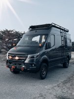
OTG Crew will be arriving early afternoon on Wednesday to secure our campsites (look for the big, blue Ram w/ camper!). You're welcome to arrive anytime you want. Before the event, or at any point through the event dates.
Raffle & Prizes
We will be giving away a number of prizes (dependent on how many folks buy raffle tickets). If you haven't bought into the raffle, tix are only $10 / each, and you can buy as many as you like
")
 Get Your Raffle Tickets
 BaseCamp Activities
- Be sure to bring games like cornhole, frisbee, etc!
- Swimming down at the river (2 minute walk)
- Hike to an abandoned lighthouse and elephant seal colony
- Hike through the tallest forest on earth (Humbodlt Redwoods)
- 3 options for daytime trail runs (3-5 hour day trips in your 4x4)
- Hang out around the campfire at night
- Kids movie night??
- Raffle with prizes
Cheap Gas/Fuel
The cheapest gas for folks coming from the south can be found at Coyote Valley Casino, about 10 minutes north of Ukiah.
Coyote Valley Casino
77 BIA Rd 228, Redwood Valley, CA 95470
Campfires + Grills/BBQs
Campfires and grills/BBQ are all permitted at AW Way. Please bring firewood if you can!
GPX File (trail runs, hikes, route to camp): coming soon!
Look for the big blue Ram when you arrive at camp
Swimming / Water Recreation
River access is a 1-3 minute walk from most campsites. The Mattole is a slow moving river that is safe for children to wade or swim. There's also a nice rock jump (about 8-10' depending on water levels). Bring your intertubes\water floaties to float lazily down river. Do bring your chairs, umbrellas and awnings to hang out down by the beach/swimming hole.
Given that the Mattole sees lower water levels in summer, kayaks and paddle boards are not recommended as the swimming area is not super big.
Field Games
The campground features a huge meadow in the middle. Perfect for field games like frisbee, frisbee gold, cornhole, football, RC trucks and more. Please bring field games if you have them!
Kids & Bicycles
There's a nice paved loop (a bit bumpy for scooters and skateboards) that's perfect for kids to ride their bikes around.
Hiking Opportunities
See below for more info!
Trail Run Opportunities
See below for more info!
Trail Runs & Hiking Opportunities
For Friday and Saturday we'll have a variety of trail run options and some hiking options as well. We'll have a QR code at the "main" camp you can use to sign up for each trail run, while the hiking (at least to Humboldt Redwoods) will be a bit more informal. The Trail Runs will typically last 2-4 hours with start times between 10-11am. There will be a cap on space, so be sure to sign up early. If there's a high amount of demand, we may see if other folks are willing to lead a second group. Group sizes will be capped at 10-12 rigs depending on the route.
If you'd be willing to lead a group, please come talk to us!
 GPX File for All Trail Runs: Download Link
Shelter Cove & Saddle Mountain
GPX File for All Trail Runs: Download Link
Shelter Cove & Saddle Mountain
Distance / Time: 77 miles, 4ish hours
Vehicle Requirements: Any 4x4 or AWD vehicle with off road tires (AT/RT/MT)
Terrain: Mixture of dirt and pavement. The road up to Saddle Mountain Road is steep and portions of the trail have become overgrown in the last 3 years. Oversized rigs like full size trucks and Sprinter Vans should expect to pick up some pinstriping.
You'll depart from camp to the quaint coastal outpost of Shelter Cove. If you get a chance, we highly recommend stopping and grabbing a bite to eat at Gyppo Ale House. Be sure to tell them OTG sent you! Lots of opportunities for outdoor games like cornhole, ping pong, and more! Swing by the old Cape Mendocino Lighthouse and take the stairs down to the tide pools wear local harbor seals and sea lions hang out on the rocks. On the way back you'll drive Saddle Mountain Road up to 3k feet, which has some of the best views of the Lost Coast.
Windy Point & Punta Gorda Lighthouse Hike (hike is optional)
Distance / Time: 27 miles round trip 2-4 hours (depending if you do the hike!)
Vehicle Requirements: Any 4x4 or AWD vehicle with off road tires (AT/RT/MT).
High Roof Sprinters are not recommended for the descent to Windy Point.
Terrain: Mixture of pavement and dirt. The road down to Windy Point is steep and off camber (high roof vans not recommend).
You'll depart camp heading west towards Mattole Beach. The drive up Prosper Ridge features some of the most incredible views anywhere along the Lost Coast. This is a simple out-and-back to Windy Point, which lives up to its name. But don't let the wind dissuade you from hiking to the abandoned Punta Gorda Lighthouse. The winds die down significantly once you drop down to the beach. Be sure to check out the infamous Humboldt truck-in-a-tree on your way back to camp!
The hike to Punta Gorda Lighthouse is approximately 2.25 miles out-and-back. Aside from the initial descent, the trail is flat following the Lost Coast Trail (hiking) which brings you to the Punta Gorda Lighthouse and elephant seal colony.
Bear River Ridge + Avenue of the Giants
Distance / Time: 90 miles round trip, 3-4 hours
Vehicle Requirements: Any 4x4 or AWD vehicle with off road tires.
Terrain: Mostly pavement with a short stretch of dirt along Bear River Ridge.
Take Mattole Road north along one of the most scenic stretches of coastline in the lower 48. You'll pass Cape Mendocino, where the Pacific Plate, Juan de Fuca (gorda plate) and North American plants all come together in the Mendocino Triple Junction (one of the most seismically active regions in North America). Take Bear River Ridge (turns to dirt) down to Scotia. Bear River Ridge features incredible views of the King Range and surrounding Humboldt and Lost Coast Regions. From Scotia, follow Avenue of the Giants back to Mattole Road. Stop for a quick snack and photo op down at the Leatherman Bar and Train Trustle. From there, follow the pavement of Mattole Road through Bull Creek Flats (tallest Redwood forest on earth and we think a more impressive drive than Ave of the Giants!) back to camp!
Hiking Options
Punta Gorda Lighthouse
Distance: 2.25 miles
You'll need to sign up for the Windy Point Trail Run to do this hike. Note, not everyone who signs up will do the hike.
Bull Creek Flats / Big Tree Loop (Humboldt Redwoods)
Take Mattole Road approximately 40 minutes west towards highway 101 until you see the signs for Big Tree Loop. The parking lot has limited space, so you may need to find legal parking along Mattole Road. Bull Creek Flat features the tallest forest on earth (39 verified trees over 350'), and the densest concentration biomass on earth! Get lost in the woods for a quick 20 minute stroll, or explore for hours on end!