overland

East Mojave Heritage Trail: Nov 19-23

Hey folks,

A few updates! First, we are doing the East Mojave Heritage Trail, which is totally different from the Mojave Road. After looking through the guide, there's a good chance we'll run segment 1 backwards (from Ivanpah to Needles) and then jump on the interstate to connect to segment 3). Also, we should be prepared for detours along the way. I've gotten some solid intel on reroutes, but given the length of the trail we don't have up to date statuses on every single trail we'll be doing, which means there's a very good possibility we'll be making some detours along the way. Given the size of the group. we'll be putting quite a bit of distance between vehicles should we encounter the need to turn around.

Food/Group Meals
It sounds like some folks are interested in this, while others are not. If anyone has an enterprise version of Notion, we could use that, or I can setup a google doc for folks to collab. LMK!
 
@OTG Ben when you have the final route, will there be a file we can upload into Gaia?

I'll likely post it early next week. Also making an update to the planned route- most likely doing Segment 1 backwards then jumping on the INterstate to connect with segment 3, also running backwards.

Here's the map I've been working on with all of the POIs, DPs, Route Segments and updated detours for tracks that were hit hard by the summer monsoons.

 
What are the thoughts behind backward segment 1 vs starting in needles? Seg 1 looks to flow into seg 3 if starting at needles
 
This seems like an awesome trail adventure opportunity. Is there a way to join the waiting list for this trip? I have been unable to join previous group trips due to schedule conflicts. My son and I would be honored to join the group if a spot opens up...
 
What are the thoughts behind backward segment 1 vs starting in needles? Seg 1 looks to flow into seg 3 if starting at needles

Hey Nick, segment 1 and 4 either end/start in needles. I was thinking we would make an attempt at the following loop. It hits the really interesting locations like:

- New York Mountains / Caruthers Canyon
- Castle Mountains
- Goffs Schoolhouse and museum (new home of the old mojave bus)
- Hole in the wall (we'll probably skip mitchell caverns as a reservation is required which will be difficult to coordinate exact dates/times)
- Lava fields at the end of Segment 3

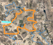
Another option would be Ludlow and run the loop in CC direction. The orange highlights the ideal loop. If we started up by Primm, the turquoise represents an escape route out via mojave road and afton canyon if we can't make the whoel trip. That wouldn't apply if we start off 40. I do think it makes sense to run it in CC direction as I would like to bring the group to both the Caruthers Canyon and Hole in the Wall as part of the xperience.

1668193349496.png
e
 
Def won't be 30-- that'd be mayhem for a multi-day run!
Are these runs that big? I got the impression they were more limited in size. Normally when we do limited runs we cap off at 6 vehicles and it's usually 1 or 2 people per. Meaning 10 or less. 30 would be a nightmare and require a professional chef and kitchen I suspect.. too much like work :)
 
Hey Nick, segment 1 and 4 either end/start in needles. I was thinking we would make an attempt at the following loop. It hits the really interesting locations like:

- New York Mountains / Caruthers Canyon
- Castle Mountains
- Goffs Schoolhouse and museum (new home of the old mojave bus)
- Hole in the wall (we'll probably skip mitchell caverns as a reservation is required which will be difficult to coordinate exact dates/times)
- Lava fields at the end of Segment 3

Another option would be Ludlow and run the loop in CC direction. The orange highlights the ideal loop. If we started up by Primm, the turquoise represents an escape route out via mojave road and afton canyon if we can't make the whoel trip. That wouldn't apply if we start off 40. I do think it makes sense to run it in CC direction as I would like to bring the group to both the Caruthers Canyon and Hole in the Wall as part of the xperience.

View attachment 1024
e
I've done most of this but rarely use pre-made routes. I never knew there was a loop though. Cool. Will there be gpx file available afterwards?
I've never done the piece north of the 15. Guess that's why I signed up on membership of this site :)
 
Are these runs that big? I got the impression they were more limited in size. Normally when we do limited runs we cap off at 6 vehicles and it's usually 1 or 2 people per. Meaning 10 or less. 30 would be a nightmare and require a professional chef and kitchen I suspect.. too much like work :)

We have 10 confirmed rigs, which is about as big as I like it. Lots of kids though, so we could have 25 total persons out on the trail for this one.

I'll be publishing the entire EMHT Route Guide by the end of the month. I've been working closely with Bill Creech, president of the MDHCA on getting all of the relevant info in there. But what I can tell you is that the GPX file, at least for our subscribers, will contain the most detailed digtail mapping assets available out there-- 100+ discovery points and 250+ total POIs.
 
Ah if only I could find a group with more families, makes them bigger but my 12 years old might enjoy it more.

Looking forward to downloading the GPX. We're going to base a trip off of the Kofa in january, 5 rigs. Not sure how much we'll adapt. Probably do a meet up in Swansea and then cut a trail south . Got a few runs out of their already logged, including a few to avoid :)

We'll probably be back down in your neck of the woods around prez day ;)
 
I've published the complete route guide to the EMHT in the routes section of the website. If you have a subscription, you can see the entire route with all of the 100+ discovery points and 200+ total POIs.

Please note, I'll be posting an updated GPX here as there are some detours we need to be mindful of. That should be posted no later than Wednesday!
 
Hey Nick, segment 1 and 4 either end/start in needles. I was thinking we would make an attempt at the following loop. It hits the really interesting locations like:

- New York Mountains / Caruthers Canyon
- Castle Mountains
- Goffs Schoolhouse and museum (new home of the old mojave bus)
- Hole in the wall (we'll probably skip mitchell caverns as a reservation is required which will be difficult to coordinate exact dates/times)
- Lava fields at the end of Segment 3

Another option would be Ludlow and run the loop in CC direction. The orange highlights the ideal loop. If we started up by Primm, the turquoise represents an escape route out via mojave road and afton canyon if we can't make the whoel trip. That wouldn't apply if we start off 40. I do think it makes sense to run it in CC direction as I would like to bring the group to both the Caruthers Canyon and Hole in the Wall as part of the experience.
Sorry, I was confusing segments 1 and 4. Makes sense to start near prim, that'll give us a gas up location.

Hole in the wall is a pretty cool stop for sure, especially the rings hike.
 
We have 10 confirmed rigs, which is about as big as I like it. Lots of kids though, so we could have 25 total persons out on the trail for this one.

I'll be publishing the entire EMHT Route Guide by the end of the month. I've been working closely with Bill Creech, president of the MDHCA on getting all of the relevant info in there. But what I can tell you is that the GPX file, at least for our subscribers, will contain the most detailed digtail mapping assets available out there-- 100+ discovery points and 250+ total POIs.
I’m coming with my 9 year old son and my 13 year old daughter.
 
I hope you guys have an epic and safe trip! My son and I will be in the area doing some exploring so maybe our paths will cross. Thank you Ben for uploading the gpx to the website! Hopefully we will make one of these group trips; I support limiting the groups size to reduce the footprint/impacts. Does anyone have spatial layers for the wilderness boundaries? We would like to a bit of gem hunting and do not want to take from protected/regulated areas.
 
I hope you guys have an epic and safe trip! My son and I will be in the area doing some exploring so maybe our paths will cross. Thank you Ben for uploading the gpx to the website! Hopefully we will make one of these group trips; I support limiting the groups size to reduce the footprint/impacts. Does anyone have spatial layers for the wilderness boundaries? We would like to a bit of gem hunting and do not want to take from protected/regulated areas.

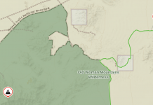
The base layers, like the Gaia Overlanding layer in Gaia GPS definitely have the wilderness boundaries in the Mojave NP. There is another layer called Wilderness Areas that you can overlay on your map if you'd like to make those areas stand out even more.

The green designated is a wilderness area:

1668473264195.png
 
I'll be caravanning down with Daniel aka @DPurdy85 leaving the North Bay sometime between noon and 1. We're looking at camping somewhere around Baker and came up with these two promising spots if others would like to join. My guess is we'll be rolling in sometime between 10pm to midnight on Friday.

I'm leaning towards Baker Burn since it definitely has quite a bit of room is closer to the Interstate (but protected by a hill).


Well, it sounds like Kiley won't be able to make it unfortunately. I've extended the invite to Mike aka @BBE_YOTA to take his spot. All of the deets can be found in the original post!
Thanks Ben! Really looking forward to adventuring with you all! My son Otto (6) is exited to overland with folks other than his parents. My truck and equipment meets the requisites. We will see you there!
 
Back
Top